Technology is playing a key role in the fight against the coronavirus disease (COVID-19). Several countries have slowed the spread of the virus with the help of digital tools for health screening and monitoring, contract tracing, and public information. Another area where technology is proving valuable is in data analysis to support decision-making.
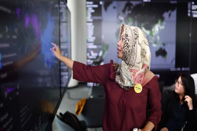
In Makassar, the capital of the Indonesian province of South Sulawesi, medical frontline workers collect data using computer tablets and mobile devices to identify pandemic hotspots and to inform emergency planning. The city uses a visual data platform called “ur-scape” to plot the data on a digital map to show how the virus is spreading.
Evidence-based urban planning
The Future Cities Laboratory at the Singapore-ETH Centre developed the tool, which it has been piloting in Makassar and three other cities in Indonesia: Bandung, Semarang, and Palembang as part of a project supported by the Asian Development Bank (ADB) and the Swiss Secretariat of Economic Affairs (SECO).
The project’s objective is to strengthen capability in evidence-based spatial planning for urban development.
Ur-scape is a geospatial tool that integrates and visualizes data at multiple scales. It helps urban planners to “identify ‘sweet spots’ and ‘stress points’ within a city”—data that can help guide land use policies, infrastructure development, and the allocation of resources.
High-risk areas
Ur-scape was used in Makassar to help decision makers assess and verify the COVID-19 situation on the ground.
The study identified the potential spatial pattern of the pandemic, potential vulnerable areas and communities, and areas that need to be monitored or managed, says Devisari Tunas, Scenario Coordinator for Archipelago Cities of the Future Cities, at an ASEAN Australia Smart Cities webinar organized by ADB in August. The study team conducted a cross-analysis of multisectoral thematic data, spatial data, and social and economic indicators.
Results of the spatial analysis showed that COVID-19 hotspots in the city coincided with high population density, says Tunas. The virus spread fast in slum areas, places with low access to clean water, and those within a 15-minute walking distance from a transport hub.
An important trading port, Makassar has one of the highest passenger traffic among Indonesian ports and the largest cargo traffic in Sulawesi.
Implications
Tunas says the results of the study indicate relationships between COVID-19 transmission patterns and the following factors:
- population density,
- land use (i.e., centers of commerce, schools, student and worker dormitories, industrial areas),
- main transport hubs and city's main arteries,
- access to water, and
- social-economic indicators (i.e., income level).
She said policymakers and urban planners need to pay attention to these factors in post-COVID planning, which requires a new paradigm and new guidelines. She remarked that results of the study underscore the need for multisectoral planning to build resilient cities.
This article was first published by BIMP-EAGA on 8 September 2020.